


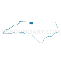
Voting District WM, Rockingham County, North Carolina
About
Outline

Summary
| Unique Area Identifier | 641295 |
| Name | Voting District WM |
| County | Rockingham County |
| State | North Carolina |
| Area (square miles) | 46.50 |
| Land Area (square miles) | 45.94 |
| Water Area (square miles) | 0.56 |
| % of Land Area | 98.80 |
| % of Water Area | 1.20 |
| Latitude of the Internal Point | 36.30255580 |
| Longtitude of the Internal Point | -79.60107630 |
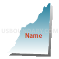
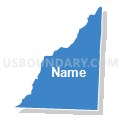
Maps


Graphs
Select a template below for downloading or customizing gragh for Voting District WM, Rockingham County, North Carolina


Neighbors
Neighoring Voting District (by Name) Neighboring Voting District on the Map
- Voting District 04, Alamance County, NC
- Voting District CO, Rockingham County, NC
- Voting District IR, Rockingham County, NC
- Voting District LOCU, Caswell County, NC
- Voting District MC, Rockingham County, NC
- Voting District NMAD, Guilford County, NC
- Voting District NWASH, Guilford County, NC
- Voting District RD-1, Rockingham County, NC
- Voting District STON, Caswell County, NC
Top 10 Neighboring County Subdivision (by Population) Neighboring County Subdivision on the Map
- Reidsville township, Rockingham County, NC (19,874)
- Madison township, Guilford County, NC (5,701)
- Township 4, Morton, Alamance County, NC (5,414)
- Williamsburg township, Rockingham County, NC (4,464)
- Simpsonville township, Rockingham County, NC (3,976)
- Stoney Creek township, Caswell County, NC (3,866)
- Washington township, Guilford County, NC (2,937)
- Locust Hill township, Caswell County, NC (2,545)
Top 10 Neighboring Place (by Population) Neighboring Place on the Map
Top 10 Neighboring Unified School District (by Population) Neighboring Unified School District on the Map
- Guilford County Schools, NC (488,406)
- Alamance-Burlington Schools, NC (151,131)
- Rockingham County Schools, NC (93,643)
- Caswell County Schools, NC (23,719)
Top 10 Neighboring State Legislative District Lower Chamber (by Population) Neighboring State Legislative District Lower Chamber on the Map
- State House District 59, NC (81,897)
- State House District 64, NC (80,704)
- State House District 91, NC (74,449)
- State House District 50, NC (73,491)
- State House District 65, NC (66,595)
Top 10 Neighboring State Legislative District Upper Chamber (by Population) Neighboring State Legislative District Upper Chamber on the Map
Top 10 Neighboring 111th Congressional District (by Population) Neighboring 111th Congressional District on the Map
Top 10 Neighboring Census Tract (by Population) Neighboring Census Tract on the Map
- Census Tract 156, Guilford County, NC (9,324)
- Census Tract 415, Rockingham County, NC (6,942)
- Census Tract 413, Rockingham County, NC (6,737)
- Census Tract 215, Alamance County, NC (4,681)
- Census Tract 416.02, Rockingham County, NC (4,614)
- Census Tract 151, Guilford County, NC (4,097)
- Census Tract 9305, Caswell County, NC (3,847)
- Census Tract 414, Rockingham County, NC (2,991)
- Census Tract 9304, Caswell County, NC (2,643)